Early Boundary Data
These pages last updated February 20, 2010
OWEN COUNTY BOUNDARY DATA (as described in Indiana Boundaries by Pence and Armstrong published Indiana Historical Bureau in 1933) according to date.
December 21, 1818: On north, the Indian Boundary per Ft. Wayne 1809, a diagonal (10 o'clock line) from northwest corner of Monroe up to just above T13N and west side of R6W. i.e., where the line encounters Vigo County. Unorganized to the north. Vigo on the west, Sullivan and Davies on the south, and Monroe to the east. County seat at hamlet of Manchester 1/2 mile up river from present day Spencer.
December 31, 1821: Some land (approx. two townships) added north of 10 o'clock line bordering on Wabash and Morgan Counties. Newly formed Putnam County took away about five townships from the northwest corner. One township bordered Vigo and one bordered Sullivan on the west while newly formed Greene County formed the southern border. Small amount of land returned by Monroe County just northeast of Gosport. County seat moved to present site of Spencer February 12, 1820.
February 12, 1825: Clay County formed on western border. Approximately four townships on western border given up to Clay. The area was one and two-thirds on the north half and two-thirds on the south half. These changes in the county land in the northwest portion may be difficult to follow in the early deed records.
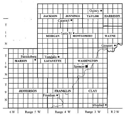
Internal and External Boundaries as of September 1861 through 1999, per research of Roger Peterson in County Commissioner's Bk 6, pgs 399, 400. Clay Township in the lower right corner of the map (T9N, R3W) is the perfect example for the numbering of the sections. Starting in the upper right with section 1, proceeding horizontally to the left to 6, 7 is directly below 6 and proceeds to the right to 12. then 13 is below 12 and so on through section 36 in the lower right. The sections number from the edges of the "T y N" and "Range x W" boundaries, and not the named townships; it is just a happy accident for this illustration that Clay Township exactly conforms to T9N, R3W.
 .
.